The Unbelievable Story of Earth’s Most Epic Flood
Be Smart・10 minutes read
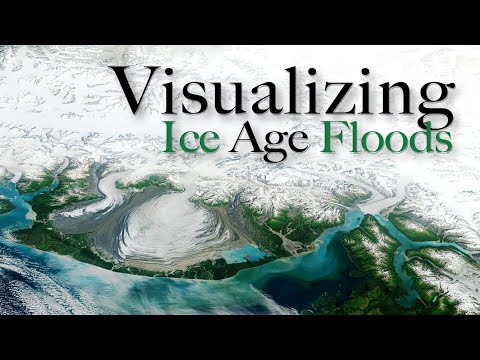
The Missoula floods in eastern Washington, caused by the failure of Glacial Lake Missoula's ice dam, reshaped the landscape in a catastrophic event of immense scale and power. The floods, which carried massive granite boulders for hundreds of kilometers, challenged existing geological theories and prompted a shift towards understanding the impact of catastrophism on Earth's history.
Insights
- Glacial Lake Missoula, formed during the last Ice Age, held more water than Lake Ontario and Lake Erie combined, eventually releasing a flood equivalent to over 10 times the flow of all rivers on Earth.
- The discovery of the Missoula floods challenged the prevailing geological theory of uniformitarianism, leading to a new understanding of catastrophism and its impact on Earth's history, illustrating the significance of cataclysmic events in shaping landscapes.
Get key ideas from YouTube videos. It’s free
Recent questions
What geological event shaped the landscape in eastern Washington?
The landscape in eastern Washington was shaped by a massive flood caused by the failure of an ice dam holding back Glacial Lake Missoula during the last Ice Age.
How did scientists initially react to the cataclysmic events in eastern Washington?
Scientists initially took decades to accept the reality of the cataclysmic events in eastern Washington, leading to a significant shift in geological understanding.
What was the volume of water released during the catastrophic flood in eastern Washington?
The catastrophic flood in eastern Washington released a volume of water equivalent to over 10 times the flow of all rivers on Earth, reshaping the landscape in a matter of days.
What geological formations in eastern Washington bear witness to the immense power of the flood waters?
The Channeled Scablands in eastern Washington bear witness to the immense power and scale of the flood waters, carrying giant granite boulders hundreds of kilometers from their origin.
How did the discovery of the Missoula floods impact geological theory?
The discovery of the Missoula floods challenged the prevailing geological theory of uniformitarianism, leading to a new understanding of catastrophism and its impact on Earth's history.
Related videos


Summary
00:00
Cataclysmic Floods Shape Earth's Landscape
- The waterfall in eastern Washington, while average in height and volume, holds a record for being created in the largest flood known on Earth.
- The flood that shaped the landscape was immense, far surpassing any modern-day event in scale.
- Scientists took decades to accept the reality of these cataclysmic events, leading to a significant shift in geological understanding.
- Glacial Lake Missoula, formed by an ice dam during the last Ice Age, held more water than Lake Ontario and Lake Erie combined.
- The ice dam eventually failed catastrophically, releasing a flood equivalent to over 10 times the flow of all rivers on Earth.
- The flood waters reshaped the landscape in a matter of days, eroding topsoil, gravel, and even bedrock.
- The Channeled Scablands in eastern Washington bear witness to the immense power and scale of the flood waters.
- The floods carried giant granite boulders hundreds of kilometers from their origin, leaving behind erratic formations.
- The floods were part of a series of events caused by repeated melting and refreezing of the ice dam, devastating the land multiple times.
- The discovery of the Missoula floods challenged the prevailing geological theory of uniformitarianism, leading to a new understanding of catastrophism and its impact on Earth's history.


