Finding Hidden Temples and Lost Nazca Lines with Satellites
StarTalk・46 minutes read
Space archaeology uses satellite data and technology to map archaeological sites, with a focus on tools like LIDAR and infrared light; Sarah Parc's work in disproving alien involvement in pyramid construction demonstrates the field's application. The Global Explorer project encourages public participation in archaeology, leading to significant discoveries and emphasizing the importance of expertise in guiding archaeological work.
Insights
- Space archaeology utilizes advanced tools like LIDAR and thermal infrared data to uncover hidden archaeological structures by mapping subtle differences in vegetation and temperature variations.
- Collaborative projects like the Global Explorer initiative engage the public in citizen archaeology, democratizing the field and leading to significant new discoveries through partnerships with local experts, showcasing the power of collective passion and skill in supporting archaeological research.
Get key ideas from YouTube videos. It’s free
Recent questions
What is space archaeology?
Space archaeology involves using space-based assets to map archaeological sites, utilizing tools like NASA satellites, commercial satellites, and drone imagery to locate and study ancient structures.
How does LIDAR aid in archaeology?
LIDAR, or Light Detection and Ranging, involves sending millions of pulse beams of light to create a 3D model of landscapes, helping in creating bare Earth models by removing vegetation points and revealing structures like pyramids or canals.
What is the significance of thermal infrared data in archaeology?
Thermal infrared data is used to measure heat differences, revealing buried chambers or tombs with temperature variations, aiding archaeologists in detecting hidden structures beneath the surface.
How does satellite imagery assist in archaeology?
Satellite imagery aids in identifying potential archaeological sites, guiding excavation efforts based on known historical data, providing valuable insights for researchers studying ancient civilizations.
What is the Global Explorer project?
The Global Explorer project aims to engage the public in structured citizen archaeology, collaborating with local experts to identify potential archaeological sites and make significant new discoveries, harnessing the crowd's passion and skill to support archaeological work on the ground.
Related videos

Katie South
ANT 200 Week 3 2 Survey and Excavation with audio

Odyssey - Ancient History Documentaries
The Race To Protect Priceless Ancient Artefacts From The British Army | Time Team | Odyssey
nature video
Lost beneath the leaves: Lasers reveal an ancient Amazonian civilisation

WIRED
Archaeologist Answers Archaeology Questions From Twitter | Tech Support | WIRED

wpsu
Geospatial Revolution / Episode One


Summary
00:00
Uncovering Archaeological Sites with Space Technology
- Space archaeology involves using space-based assets to map archaeological sites.
- Conversations are increasing between planetary scientists and NASA regarding mapping the moon, Mars, and Venus.
- Sarah Parc, an archaeologist and Egyptologist, specializes in disproving the theory that the pyramids were built by aliens.
- Space archaeology utilizes various tools like NASA satellites, commercial satellites, and drone imagery to locate archaeological sites.
- Sarah Parc's work involves using different parts of the light spectrum to map subtle differences on archaeological sites.
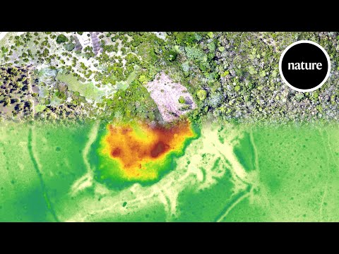
- Near-infrared light is crucial for mapping vegetation health and differences in vegetation caused by buried structures.
- LIDAR, or Light Detection and Ranging, involves sending millions of pulse beams of light to create a 3D model of landscapes.
- LIDAR helps in creating bare Earth models by removing vegetation points, revealing structures like pyramids or canals.
- LIDAR data can uncover previously unknown structures, as seen in a study in New Orleans where 880,000 structures were found.
- Radar data can penetrate the ground to a certain depth, useful for detecting buried features like river courses or ancient settlements.
15:49
Infrared Satellite Data Enhances Archaeological Discoveries
- Thermal infrared data is used to measure heat differences, revealing buried chambers or tombs with temperature variations.
- Infrared light, part of the light spectrum, is utilized to detect subtle temperature differences for archaeological purposes.
- Active satellite data, receiving reflected light, is used alongside passive satellite data to analyze vegetation, soil, and water variances.
- Remote sensing software, like TurboTax, is employed with free NASA satellite imagery and affordable commercial satellite data.
- Ground truthing involves targeted site visits to verify potential archaeological sites, optimizing time and resources.
- Historical aerial archaeology led to modern aerial reconnaissance, enhancing military and archaeological practices.
- Laser technology, providing point cloud data for topography, aids in archaeological site identification.
- Geophysical advancements have reduced false positives in site identification, improving efficiency in archaeological fieldwork.
- Satellite imagery aids in identifying potential archaeological sites, guiding excavation efforts based on known historical data.
- Egypt's extensive occupation history, spanning thousands of years, results in layered cities with intact structures buried beneath modern urban areas.
31:23
Global Explorer: Uncovering Archaeological Discoveries Worldwide
- Excavated one 1,000th of 1% of the S yellow, leading to ongoing discoveries worldwide.
- Access to data through technology has democratized archaeology, allowing amateurs to participate.
- The Global Explorer project aims to engage the public in structured citizen archaeology.
- The platform initially focused on Peru, collaborating with local archaeologists and finding significant new discoveries.
- Over 30,000 potential anthropogenic features were identified, with 800+ confirmed as significant new findings.
- Collaboration with local experts led to the discovery of new Nasca lines in Peru.
- The project harnesses the crowd's passion and skill to support archaeological work on the ground.
- Challenges arise from individuals substituting imagination for scientific expertise.
- The importance of expertise and training in archaeology is highlighted, emphasizing the need for guided participation.
- Archaeology provides a framework for understanding civilizations, applicable to studying other planets and potential extraterrestrial life.
46:32
"Interconnectedness of Science and Continuity of Civilization"
- Moon meteorites are abundant on Earth, suggesting the possibility of Earth meteorites on the moon, prompting the search for stowaway microbes as evidence of past existence.
- Rocks moving between planets raise the question of how much meteorite material would remain intact upon impact with the moon, considering factors like erosion and weather absence.
- The idea of continuity connects civilizations globally, persisting through environmental changes, wars, and diseases, offering hope amidst challenges like climate change and authoritarianism.
- The cross-pollination of tools and methods across scientific disciplines highlights the interconnectedness of all branches of science, emphasizing the shared curiosity driving exploration and discovery.


